

20 years
of GPR diagnostics, processing development, consulting and field surveys
3 patents
co-invented by our founder, PhD in GPR imaging and signal processing, with published work
4 continents
AMG surveys in North America, Europe, Africa and Polynesia
50+
projects worldwide in the team’s experience
What you receive
-
Maps of every layer and every finding
-
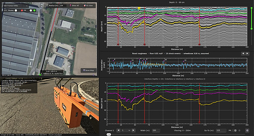
The report, and the survey itself in AMG Viewer Edition on your computer: every finding at its place on the map, to be queried years later, for tracking and monitoring. One year of licence included
-
Exports to Excel, CSV, DXF, GeoJSON, LandXML, Shapefile and KMZ for your GIS and CAD
What ground penetrating radar measures
-
Layer thicknesses along the whole section
-
Moisture, voids and delamination
-
Cracks, and in structures the reinforcement and the prestressing cables

Why trust the data

-
AMG Software, our own processing chain, built on twenty years of GPR research and on what our clients need
-
Strict methodologies and processes for on-site data collection
-
Years of experience with the equipment of the major GPR manufacturers and with other non-destructive methods
-
Each client and each project treated as unique: the equipment and the methods adapted to the client’s needs
Independent of the equipment manufacturer
-
The manufacturers sell instruments. AMG is the diagnostics expertise
-
Choose GSSI, Kontur or other manufacturers: the system that fits your needs
-
AMG Software processes the data whatever the manufacturer; AMG Viewer Edition delivers the diagnosis and unlocks automatic reporting, on your computer

Predict. Prevent. Preserve.
Maintenance by condition, not by calendar. In Finland alone, the state network’s repair backlog stood at 4.3 billion euros at the end of 2025, 2.6 billion of it on roads (Väylävirasto, 2026).
-
Predict: plans you can defend. Finland’s road agency already chooses its repaving from measured condition and backs its structural plans with bearing-capacity and ground-penetrating-radar surveys (Minister of Transport and Communications, 2025).
-
Prevent: lower lifecycle cost, fewer sudden closures. One dollar spent on preservation at the right time eliminates or delays six to ten dollars of rehabilitation or reconstruction later (Transportation Research Board, 2003).
-
Preserve: longer asset life, no coring, no closure. Each extra metre per kilometre of roughness raises car fuel use by 2 to 3 percent (Zaabar and Chatti, 2014).
A selection of projects delivered in the last three years
Tahiti Faa’a international airport, French Polynesia, 2026
Airfield.
Client: the airport’s operating company.
Survey of the whole airfield, runway, taxiways and aprons, with GSSI systems, carried out with Aquitaine Radar.
Question: the pavement structure and the layer thicknesses.
Delivered: the structure maps and the report.
LGV Sud Europe Atlantique, France, 2024
High-speed railway.
Client: LISEA, the concession company that operates the Tours to Bordeaux high-speed line.
Ground penetrating radar survey of both tracks near Bordeaux with GSSI and Kontur systems.
Question: the condition of the ballast and the subgrade, moisture and other issues.
Delivered: layer and moisture maps and the report.
Transgabonais railway, Gabon, 2025
Railway.
Client: Loram Finland, the maintenance contractor.
Survey of the 650 km main line from Libreville to Franceville with GSSI systems.
Question: the condition of the trackbed and the embankments, the waterlogged zones.
Example GPR surveys you can open yourself
Three demo surveys come with the Viewer: a road, a motorway and a 3D GPR survey, with their maps, photographs and findings. Download the Viewer and open them on your own computer.
Tell us about your roads, airfields, railways or structures: we propose a survey plan, with examples from similar projects, within one working day.